


Zoar Voting District, Lincoln County, Missouri
About
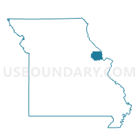
Outline

Summary
| Unique Area Identifier | 608987 |
| Name | Zoar Voting District |
| County | Lincoln County |
| State | Missouri |
| Area (square miles) | 19.90 |
| Land Area (square miles) | 19.70 |
| Water Area (square miles) | 0.20 |
| % of Land Area | 99.02 |
| % of Water Area | 0.98 |
| Latitude of the Internal Point | 38.89560020 |
| Longtitude of the Internal Point | -91.03213090 |
Maps


Graphs
Select a template below for downloading or customizing gragh for Zoar Voting District, Lincoln County, Missouri


Neighbors
Neighoring Voting District (by Name) Neighboring Voting District on the Map
- 183-Foristell Voting District, St. Charles County, MO
- Elkhorn North Voting District, Warren County, MO
- Hawk Point Voting District, Lincoln County, MO
- Moscow Mills Rural Voting District, Lincoln County, MO
- North Hickory Grove Voting District, Warren County, MO
- Weeks Voting District, Warren County, MO
Top 10 Neighboring County Subdivision (by Population) Neighboring County Subdivision on the Map
- Wentzville township, St. Charles County, MO (39,997)
- Clark township, Lincoln County, MO (10,395)
- Hickory Grove township, Warren County, MO (9,326)
- North Elkhorn township, Warren County, MO (7,412)
- Hawk Point township, Lincoln County, MO (2,472)
- Camp Branch township, Warren County, MO (1,018)
Top 10 Neighboring Place (by Population) Neighboring Place on the Map
Top 10 Neighboring Unified School District (by Population) Neighboring Unified School District on the Map
- Wentzville R-IV School District, MO (71,390)
- Troy R-III School District, MO (33,238)
- Warren County R-III School District, MO (18,599)
- Wright City R-II School District, MO (10,768)
Top 10 Neighboring State Legislative District Lower Chamber (by Population) Neighboring State Legislative District Lower Chamber on the Map
- State House District 13, MO (72,365)
- State House District 11, MO (48,326)
- State House District 99, MO (42,788)
Top 10 Neighboring State Legislative District Upper Chamber (by Population) Neighboring State Legislative District Upper Chamber on the Map
Top 10 Neighboring 111th Congressional District (by Population) Neighboring 111th Congressional District on the Map
Top 10 Neighboring Census Tract (by Population) Neighboring Census Tract on the Map
- Census Tract 8103.03, Lincoln County, MO (8,180)
- Census Tract 8201.01, Warren County, MO (7,236)
- Census Tract 8201.03, Warren County, MO (7,141)
- Census Tract 3120.97, St. Charles County, MO (6,639)
- Census Tract 8102.01, Lincoln County, MO (6,535)